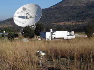
Figure 1. This picture of HartRAO show three of the main Geodetic system used: (a) Radio Observatory (the dish on the left), (b) SLR (just right of the Radio Observatory), and (c) GPS receiver (in the foreground).
About Us
Space Geodesy is one of the programmes of the Hartebeesthoek Radio Astronomy Observatory
What is HartRAO
Hartebeeshoek Radio Astronomy Observatory (HartRAO),
situated just north of Johannesburg, currently has three main divisions: radio
astronomy, space geodesy and science awareness. The space geodesy programme
was a progeny of radio astronomy, as there is much synergy between geodetic
Very Long Baseline Interferometry (VLBI) and radio astronomy techniques. The
Space Geodesy Programme developed considerably during the last few years. With
the addition of Satellite Laser Ranging (SLR) and Global Positioning System
(GPS) to HartRAO, the facility has become one of only five fiducial geodetic
sites in the world.
The complete profile of HartRAO is that of an international facility, rather
than just a national facility. Its strategic location, ability to deliver,
dedicated staff and strong leadership has made it a facility which is
recognised internationally. Most of HartRAO's projects are therefore large
international projects which allow local scientists to have access to global
science and create the avenues towards new developments, capacity building and
local expertise. Projects operate within the standards and guidelines of
internationally recognised bodies, such as the International Association of
Geodesy (IAG), International Astronomical Union (IAU) and their related
services and commissions.
|
Figure 1. This picture of HartRAO show three of the main Geodetic system used: (a) Radio Observatory (the dish on the left), (b) SLR (just right of the Radio Observatory), and (c) GPS receiver (in the foreground). |
The Future of Geodesy and HartRAO
The scenery of space geodesy is changing as the need has been identified to
improve the geometrical distribution of fundamental stations and to improve
the accuracy and sampling rates of instrumentation. The location of space
geodesy equipment at HartRAO is partially a spin-off from the NASA deep space
tracking programme, the consequent CSIR establishment of radio astronomy
utilising the tracking antenna, and the efforts from the space geodesy
programme to collocate GPS and SLR with the telescope. The site was never
"selected" as such in terms of scientific requirements based on astronomical
seeing and cloud coverage criteria, so it is not optimally located for
scientific output.
The future of space geodesy globally, is in the process of development and
installation of dedicated geodetic VLBI antennas, (VLBI2010 project), KHz
satellite laser ranging (SLR2000), denser GPS networks (AFREF) and the
dissemination of data in near real-time. This concept is termed GGOS, an
acronym for Global Geodetic Observing System, which is the first and only
project of the newly restructured International Association of Geodesy (IAG).
This system will continue to maintain the International Celestial Reference
Frame (ICRF) and will provide necessary parameters such as Earth Orientation
Parameters (nutation, precession, time etc.) to the global scientific
community, astronomy of course being a major user of this product.
Basically GGOS views the Earth system holistically by including the solid
Earth, the fluid components and static and time-varying gravity field in its
products. This concept combines different techniques, models, and approaches
in order to achieve a better understanding of geodetic, geophysical and
geodynamical processes. GGOS will provide the scientific and infrastructural
basis for all geodetic global change research. This IAG Project commenced with
the definition phase in 2003 and is based on the IAG Services.
VLBI 2010 will operate at S, X and Ka bands. The present HartRAO telescope
cannot operate efficiently at Ka band (32 GHz). VLBI2010 requires dedicated,
24 hour geodetic measurements monitoring earth rotation to find sub-diurnal
rotational variations on the micro-arcsecond level as well as dedicated
equipment to monitor Total Electron Content of the ionosphere, maintenance and
expansion of the ICRF etc. Currently only 15 % of the HartRAO telescope is
allocated to space geodesy which is a fraction of what is required.
Air pollution, proximity of large cities and industrial areas impose severe
restrictions on HartRAO as a facility to expand and improve its activities in
Satellite Laser Ranging and Lunar Laser Ranging.
What is the Matjiesfontein Outstation?
Given all the problems and restrictions imposed on HartRAO as stated above, it
is essential to relocate all the Geodesy related work from HartRAO to a new
location. The Matjiesfontein Outstation is the proposed new Space Geodesy site. This site will host all four
aspects of Space Geodesy:
The SLR will also be enhanced to do Lunar Laser Ranging (LLR), which means that South Africa will be the only country in the southern hemisphere to do LLR. Three diferent sites in South Africa are being looked at as possible locations for this Outstation:
This page was last updated on 2008/05/07 04:52 -0700 by Roelf Botha