Tide Gauge
| The GPS Tide Gauge Benchmark
Monitoring - Pilot Project (TIGA-PP) is a pilot study of the International
GPS Service (IGS). The main objective of TIGA is establishing a service to
analyse GPS data from stations at or near tide gauges on a continuous basis.
The primary product of the service is time series of coordinates of tide
gauges and associated benchmarks. This product will allow distinction between
absolute and relative sea level changes by accounting for the vertical
movement of the station.
TIGAsA is a collaborative project
between HartRAO, NASA(JPL), the SA NAVY (Hydrographic Office) and several
other partners.
Within TIGA, TIGAsA will function as
a TIGA Associate Analysis Centre (TAAC), TIGA Data Centre (TDC) and will
install and maintain TIGA Observing Stations (TOS).
|
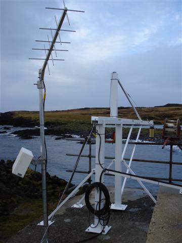 The
Tide Gauge (gold-coloured tube at end of boom) with the communications
equipment, located at Marion Island. |
Introduction
TIGAsA was initiated by the Hartebeesthoek Radio Astronomy
Observatory (HartRAO) in response to the "Call for Participation" letter from
the IGS, which solicited participation by agencies in the functions and
objectives of TIGA. HartRAO was already in the process of installing GPS
equipment at tide gauges and saw TIGA as an essential project to address the
problem of analysing vertical motions at tide gauges on a global scale.
A meeting was subsequently organised and held (27 July 2001) at
Environmentek (CSIR), Stellenbosch with possible participants. This meeting
culminated in TIGAsA, the southern Africa component of TIGA.
Objectives
The objectives of TIGAsA have been identified within the framework of the
objectives of TIGA, but have a regional approach
- Establish, maintain and expand a regional continuous GPS
@ Tide Gauge network, which will form part of the TIGA global CGPS @ TG
network.
- Function as a TIGA Associate Analysis Centre (TAAC)
Function as a TIGA Data Centre
The following are TIGA stations mainained by
HartRAO:
-
Simonstown (SIMO)
-
Richardsbay (RBAY)
-
Marion Island (MARN)
This page was last updated on
2008/11/20 15:07 +0200 by
Roelf Botha