Satellite Laser Ranger
 | Hits: 11394
Translations: Danish, French
Satellite Laser Ranging (SLR) is a technique used to determine the position of the earth and of the satellites relative to each other. In satellite laser ranging a global network of stations measure the instantaneous roundtrip time of flight of ultra short pulses of light to satellites equipped with special reflectors. This provides instantaneous range measurements of millimetre level precision which can be accumulated to provide accurate orbits and a host of important science products.
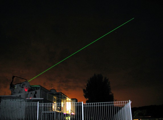
The SLR system (MOBLAS6) currently in use at HartRAO
To track a satellite successfully one must simultaneously obtain the following information:
-
The satellite being tracked
-
Pointing coordinates
-
Time at instant of successful track
- Time of flight of laser pulse (from which distance is calculated)
This information constitutes all the necessary components for Data Processing & Storage as seen in the basic SLR diagram.
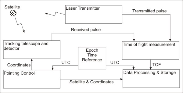
A basic SLR system diagram
Accurate timing is the most important aspect, for both the instantaneous time according to UTC and the time interval measurement for the time of flight of the laser pulse. The Epoch time reference consists of a very accurate clock, usually more accurate than 10¹² parts of a second, which supplies precise time signals to both the Pointing Control and the Data Processing & Storage subsystems.
The Pointing Control subsystem use the time information together with estimated orbital data of the specific satellite to calculate the estimated pointing coordinates. The satellite location is usually quite close to this and by scanning through a certain range of offsets the satellite can be found.
The laser exit path and the telescope are co-mounted so that they point in exactly the same direction. If a laser pulse is reflected against one of the retroreflectors on the telescope the light returns along the same path towards the telescope and ultimately the detector.
A successful detection of the returned laser pulse implies that the satellite position has been acquired and a data-point can be sent to the Data Processing & Storage subsystem. Since satellite orbits range from ~ 500 km to ~ 22 000 km, the time of flight of the laser pulses are about 3.3 to 147 ms (from emission till detection). Also keep in mind that for millimetre precision one must be able to measure accurately down to the 3.3 ps level!
At HartRAO we operate a NASA system: MOBLAS-6. The official inauguration of MOBLAS-6 took place on 20 November 2000. During the day there was a workshop to discuss the SLR technique and present some of the scientific achievements which SLR has contributed to. MOBLAS-6 was dedicated officially by Minister Ngubane, the minister of the Department of Arts, Culture, Science and Technology. The brochure on MOBLAS-6 and the Geodesy Programme which was handed out during the day of dedication can be downloaded here as a PDF file MOBLAS-6.
An in-depth description of the MOBLAS-6 systems can be found here