Radio Telescope (VLBI)
 |
|  | Hits: 20028
Translations: French
Introduction
Radio Telescopes are utilised in Geodesy for VLBI (Very Long Baseline Interferometry), which is the most accurate geodetic technique for determining both the terrestrial and celestial reference frames (TRF & CRF). This in turn helps one to determine Earth's orientation in space. For the past four decades geoscientists have used the data products delivered by this technique in scientific applications such as investigating the changing Earth. Demand for an increase in both performance and accuracy required that a new set of criteria be laid down for a future geodetic VLBI system. This is envisioned as VLBI2010.
Technique
Geodetic VLBI is a space-based technique which allows for accurate measurement of the Earth and its orientation in inertial space. An inertial frame is defined by compact radio sources, billions of light years from Earth, called quasars. The Earth’s orientation in this inertial reference frame is measured. The quasarsare observed with a global network of radio telescopes. Telescopes in the network simultaneously record signals from quasars together with signals from local atomic clocks onto hard disks. At the correlator, data are played back to determine differential time delays. From these differences in arrival times of signals at the various telescopes, the baselines between the telescopes can be determined with an accuracy of a few millimetres. In addition, VLBI data allows us determine the CRF and TRF and to measure Earth orientation parameters (EOP) as well as tropospheric parameters.
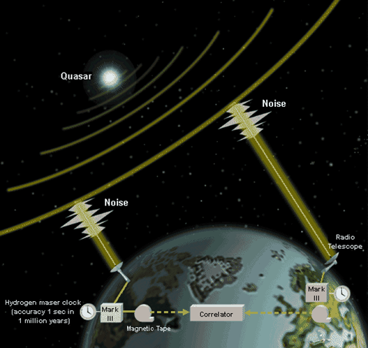
Fig1. Geodetic VLBI concept – radio telescopes on different continents observe quasars and the differences in signal arrival times are used to estimate the distance between telescopes.
(from http://lupus.gsfc.nasa.gov/files_documents/vlbi_brochure_1990s/vlbi_concept.gif)
Applications
Only geodetic VLBI provides the link between the CRF and TRF necessary for determining the Earth’s orientation in inertial space.
Geodetic VLBI allows for accurate measurement of :
• positions and velocities of sites occupied by VLBI antennas
• Earth Orientation Parameters (EOP) – UT1, polar motion, nutation, precession
• Troposphericparameters – total and wet zenith path delays, meteorological data for stations
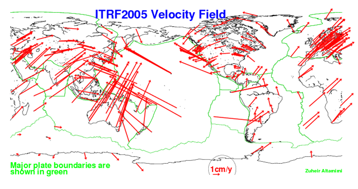
Fig2.Station velocities (from http://itrf.ensg.ign.fr/ITRF_solutions/2005/ITRF2005.php)
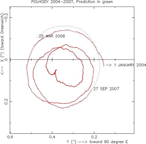
Fig3.Motion of the pole (from http://hpiers.obspm.fr/eoppc/eop/eopc04/eopc04-xy.gif)
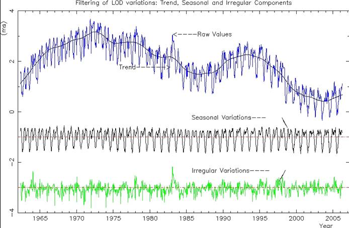
Fig4. Variations in the duration of the day (from http://hpiers.obspm.fr/eop-pc/earthor/ut1lod/figure3.html)
Knowing the Earth’s orientation in inertial space and positions of VLBI antennas on Earth allow geoscientists to model phenomena that change Earth orientation (such as atmospheric angular momentum, ocean tides and currents, elastic responses of solid Earth) and station positions (such as tectonic plate motions, deformation of crust near faults, post-glacial rebound, volcanic activity).
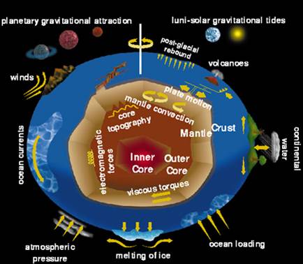
Fig5. Factors influencing Earth’s motion (from http://lupus.gsfc.nasa.gov/files_documents/vlbi_brochure_1990s/vlbi_concept.gif)
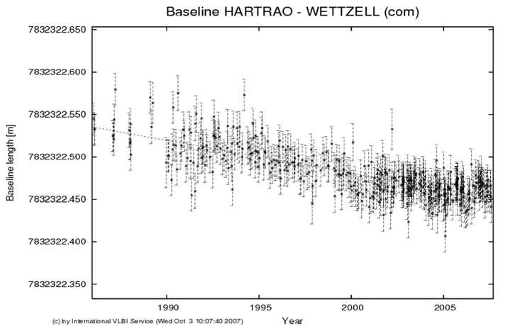
Fig6.HartRAO-Wettzell baseline (from http://vlbi.geod.uni-bonn.de/baseline-project/plot_com_362.png)
Geodetic VLBI at HartRAO
Geodetic VLBI experiments are performed almost daily with a global array of radio telescopes (Fig7.) observing the approximately 50 radio sources. HartRAO participates in 52 of these experiments annually. The 26-m Hartebeesthoek radio telescope (Fig8.) is the only telescope on the African continent participating in geodetic VLBI experiments. It forms the absolute reference point for the Hartebeesthoek94 datum.
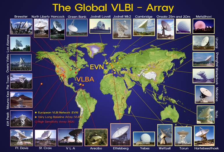
Fig7. ©T. Krichbaum, MPIfR
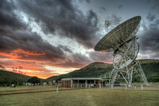
Fig8. Credit: Thomas Abbott
During a geodetic VLBI experiment, the signals from extra-galactic radio sources are collected by the 26-m telescope and channelled to receivers for wavelengths at which geodetic VLBI operate, namely 3.5 cm and 13 cm. The signal is amplified, time-stamped and recorded to disk (Fig10.) by the Mark5A recorder (Fig9.). The time-stamp is provided by a highly accurate hydrogen maser atomic clock.
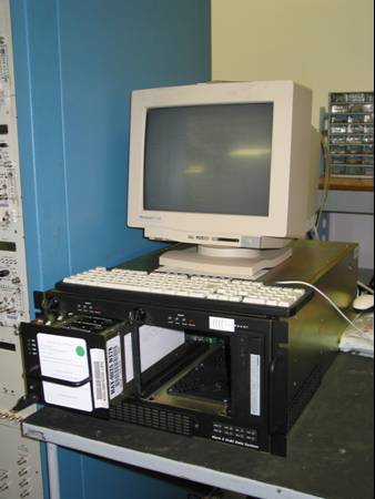 |
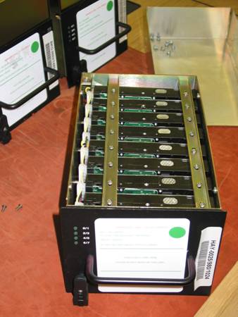 |
The disk pack with data is sent to the correlator where raw data from the stations are combined and processed to produce data bases which are sent to data centres for holding. Analysis centres retrieve data bases from data centres and generate scientific products.
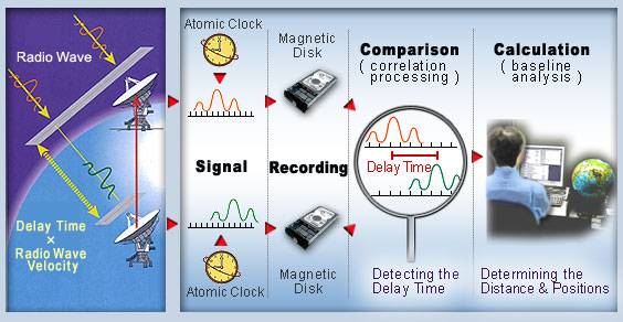
Fig11.From observations to results (from http://vldb.gsi.go.jp/sokuchi/vlbi/en/whatisvlbi/principle.html)
VLBI2010
Due to ageing antennas, deteriorating RFI environments, obsolete electronics and high operating costs, it is difficult to sustain required levels of accuracy, reliability and timeliness with the current geodetic VLBI system. Recent advances in antenna manufacture, digital electronics and data transmission technology have made it possible to visualize a new instrument capable of meeting demands for greater accuracy, continuous data flow and shortened times to product delivery.
VLBI2010 goals:
• Accuracy - 1 mm for site positions, 1 mm/year for velocity (TRF)
• EOP - continuous measurement
• IVS products - rapid generation and distribution
VLBI2010 recommendations:
• small antennas
• high-speed data networks, high-data-rate disks
• automate operations and procedures
| Current | VLBI2010 | |
| Antenna Size | 5 - 100 m dish | ~ 12 m dish |
| Slew speed | ~ 20 - 200 deg / min | > 360 deg / min |
| Sensitivity | 200 - 15 000 SEFD | < 2 500 SEFD |
| Frequency Range | S / X band | ~ 2 - 18 GHz |
| Recording Rate | 128 / 256 Mbps | 8 - 16 Gbps |
| Data Transfer | Usually ships disks, some e-transfer | e-transfer, e-VLBI, ship disks when required |
HartRAO and VLBI2010
Establishing a new space geodesy observatory, the International Institute for Space Geodesy and Earth Observation (IISGEO), at Matjiesfontein will allow HartRAO to assist in realising the VLBI2010 vision. VLBI2010 collocation requirements will be met with VLBI, GNSS and SLR/LLR to be located on-site. GNSS and VLBI observations are affected similarly by atmospheric effects, allowing for an estimation of the common atmosphere. Matjiesfontein meets VLBI2010's site selection criteria of a benign atmosphere and reduced radio frequency interference. Technology developed for KAT/MeerKAT/SKA can be utilised to produce the low-cost, small, fast-moving antennas as well as the feeds and receivers proposed by VLBI2010. HartRAO is the only African representative in the international geodetic VLBI network. The network will be weakened considerably should we not be able to meet VLBI2010 requirements.
References
Behrend, D. [et al.], 2007. VLBI2010. [Poster] Presented at the IUGG XXIV in Perugia, Italy, July 2-13, from Joerg Wresnik’s Homepage.Accessed on 24 September 2007.
http://mars.hg.tuwien.ac.at/~wresnik/IUGG2007_VLBI2010_final.pdf
GSFC VLBI Group, 1995. VLBI - Measuring Our Changing Earth. [Online brochure], from the Goddard Space Flight Center website. Accessed on 24 September 2007.
http://lupus.gsfc.nasa.gov/files_documents/vlbi_brochure_1990s/
IVS Working Group 3, 2005.VLBI2010: Current and Future Requirements for Geodetic VLBI Systems. Report of Working Group 3 to the IVS Directing Board, September 16. Accessed on 24 September 2007.
ftp://ivscc.gsfc.nasa.gov/publications/memos/ivs-2006-008v01.pdf